About the Map Department
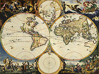
- Nicolas Joannes Visscher: map of the world
As early as the 16th century maps, atlases, and books on geography were being collected in the Viennese Imperial Court Library. In 1906 a special collection for geography – today’s Map Department – was founded, and since 1956 the world’s only globe museum has been affiliated with it.
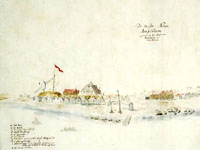
- View of New York, c. 1650
After the end of the First World War a decisive expansion of the holdings took place through the acquisition of maps, atlases, and geographic-topographic views (views of cities and landscapes) of the former Habsburg Family Fidei commis Library, of the Albertina Graphics Collection, and of the Military Geographic Institute. In the period between the World Wars the planned expansion of the so-called “Vues” collection (views) was begun.
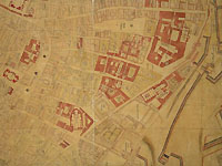
- Werner Arnold Steinhausen: Vienna, 1710
The holdings of the Department, which make it one of the most important institutions of its kind, include about 295,000 maps, 45,000 geographic-topographic views, about 800,000 picture postcards, 700 globes, 100 reliefs and models of fortresses, as well as about 83,000 volumes of technical literature and atlases.
Contact
Map DepartmentJosefsplatz 1
Left door, lift
1015 Wien
Tel.: (+43 1) 534 10-297
Fax: (+43 1) 534 10-319