The Georama
|
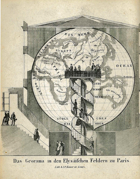
Gemeinnütziger Geschäfts-Kalender für alle Religions-Gesellschaften der österreichischen Monarchie : auf das Schaltjahr 1848. – Graz : Verlag von J. Fr. Kaiser : Gedruckt mit C. Tanzer'schen Schriften, [1847]. Austrian National Library, shelfmark: 310.139-B.Alt-Mag The Grazer Kalender of 1848 contains the image of a georama (image at left), accompanied by curios such as the so-called Hydrarchos or sketches from the satyrical weekly Fliegende Blätter. The georama itself was never meant to satisfy the sensation-seeking crowds, but to procure the geographical knowledge of the time to a wider public, in a manner easily intellegible to all. The concept of the georama had been developed by Charles-Antoine Delanglard, a French fiscal officer, and presented to the Geographical Society in Paris in 1822. The Society appraised the project, and its inventor consequently applied for a patent. The idea was equally simple as it was ingenious. Whereas the traditional model globe provides the observer with only a partial view of the planet, Delanglard put the visitors on a platform in the center of the globe, offering a panorama view of the earth. Delanglard’s georama, favourably situated at the corner of Rue de la Paix and Boulevard de Capucines, opened in May 1825. The globe, 30 m in perimeter and with a staircase leading to two platforms in the center, was made of varnished linen, enabling the light to penetrate the material. The map of the earth had been painted on the fabric with watercolours. Well-known geographer Edmé François Jomard supervised the installation of the georama, entrusting Vivien de Saint-Martin with the setup of the actual map. The georama was well-attended by the public and supported by renowned scientists like Alexander Humboldt, but still the enterprise didn’t meet the hoped-for success, and Delanglard was faced with financial difficulties. Shortly after his death, the georama was pulled down in 1832. Guérin’s New Georama The idea of the georama was taken up in the early 1840s by Charles Auguste Guérin. Again it was Vivien de Saint-Martin who undertook the realisation of the project, in collaboration with a fellow-member of the Geographical Society, architect Marc Jodot. The globe was erected in an elegant timber building situated in the Champs Elysées gardens, its perimeter measuring 32m and its diameter measuring about 10m. Iron rings served as meridian and parallel arcs, covered by a bluish, transparent varnished silk. From the entrance, located at the “South pole”, spiral stairs led to a platform on equatorial level (view image). The map was painted in a scale of 1 : 770.000, in accordance with the geographical knowledge of the time and considering most recent information provided by the exploreres of Africa and North America.
The new georama opened on June 1st, 1844, and was visited by a commission of the Academy of Sciencies who judged it very favourably and recommended it as a means for teaching geography. An article published in L’Illustration. Journal Universel suggested the establishment of georamas in all major cities. But Guérin’s enterprise, too, had already disappeared when James Wyld, publisher and cartographer, had a georama built in London. The so-called “Great Globe”, the last of its kind, was erected on Leicester Square in 1851 (just in time for the world exposition) and lasted until 1862. |