Holdings

- Andreas Cellarius: Celestial chart, 1661
The Map Department administers about 290,000 map sheets, 45,000 geographic-topographic views, 800,000 picture postcards, 650 globes, 100 reliefs and models of fortresses, as well as about 81,000 volumes of technical literature and atlases.
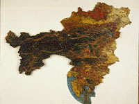
- Relief of the Austrian Monarchy
Because there is a media law obliging delivery of a sample to the Library, later maps and views published in Austria are present almost in their entirety. Among foreign publications those best represented are official maps. In acquiring literature the ANL aims mainly at material on the history of geography, cartography and ethnology, geographical discoveries and journeys, as well as studies on Austria in its modern form and the former Empire.
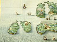
- Atlas Van der Hem 1662-78. Banda Islands
Although modern maps of all countries have been systematically acquired for several decades – with central Europe as the regional point of major interest – the worldwide prominence of the Map Department is grounded principally on its holdings of old materials. One of the most precious holdings is the famous "Atlas Blaeu-Van der Hem", a Baroque collector’s atlas of 50 volumes with about 2,100 beautifully coloured copperplate prints and hand drawings. The work was brought to Vienna by Prince Eugene of Savoy.
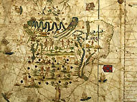
- S. Gutiérrez: world map (South America), 1551
Of the innumerable other unique items in the collection we mention: a map of the world drawn on parchment, 3.5 metres x 1 metre, in Portulan style, made in 1551 for Emperor Charles V in Seville by the cartographer Sancho Gutièrrez; and the oldest extant map of Upper and Lower Austria.
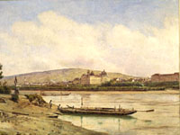
- Jacob Alt: Klosterneuburg, 1847
Among the views too there are many precious objects, among them many copperplates and woodcuts from the 16th and 17th centuries. Worthy of particular mention are the watercoloured engravings of Laurenz Janscha and Franz Ziegler and the original views of the Danube by Jacob Alt. From the 19th century there are the surprisingly exact watercolours by the Königgrätz cleric Johann Venuto, and the sketches of Greenland and Franz-Josef-Land by the Austrian polar explorer Julius Payer.